Airborne LIDAR Mapping
The greatest hazard to human life posed by hurricanes is drowning in a storm surge. Historically, surge has accounted for more than 90 percent of fatalities. Salt-water flooding is also a major cause of damage, generally only insurable through the National Flood Insurance Program (NFIP).
Accurate topographic information is essential for predicting storm surge flooding and damage. Unfortunately, existing topographic data usually consist of U.S. Geological Survey maps produced at 5 to 10 foot contour intervals. In low relief coastal plains, poor resolution can result in large flood prediction errors and has triggered massive over-evacuations. In the case of Hurricane Floyd in 1999, three million Americans got in their cars and tried to escape this advancing category 4 storm. In addition, these topographic maps are often out of date and hence do not consider the extensive development during the last few decades. Re-mapping has not been undertaken due to the cost and time required when utilizing conventional ground surveying or photogrammetry.
Airborne LIDAR mapping (Light Detection And Ranging) is an emerging technology that can provide unparalleled topographic data for construct of highly accurate digital elevation models (DEMs).
LIDAR is an active remote sensing technology that is eye-safe when deployed at standard operating altitudes. It can inexpensively acquire topographic data of unprecedented detail and accuracy. Millions of precise data points can be collected in a single day. This task would previously have taken a team of 100 men and women a lifetime to accomplish. LIDAR maps are routinely good to 6 inch accuracy — an order of magnitude better than existing maps with 5 foot contours. Five feet is literally the difference between getting your feet wet and drowning.
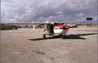
The IHRC at Florida International University and the University of Florida Geomatics Program were the first universities in the United States to jointly purchase an airborne LIDAR mapping system (in 1999). The Optech 1210 system was installed in a dedicated platform (Cessna 337 twin-engine aircraft); it utilizes a 10 kHz pulsed infrared laser, deployable at elevations from 350 to
2,000 m.
By varying the scan angle, scan rate, and flight elevation, a wide range of point spacing is obtained (e.g., 5 to 10 foot spacing is typical). In 2001 the Optech 1210 LIDAR system was up-graded to a 1233 unit, allowing 33,000 measurements to be obtained per second, greatly increasing data collection per hour of laser operating time. This near-infrared laser cannot penetrate water; therefore, only subaerial areas are surveyed.

Airborne LIDAR Mapping Schematic
Airborne LIDAR data were acquired in all areas of Miami-Dade, Manatee, Palm Beach and Broward Counties that can be affected by storm surge flooding. Data acquisition began in Summer 2000 and ended in Spring 2004. At the conclusion of the project more than 3.2 billion elevation points were collected in the participating counties.
Airborne LIDAR systems obtain measurements for horizontal coordinates (x, y) and elevation (z) of reflective objects scanned by the laser beneath the flight path. Laser-scanned objects include buildings, vehicles, vegetation, and “bare ground.” To generate a digital elevation model (DEM), measurements from non-ground features have to be identified, classified, and removed. Removing such points from LIDAR data has proved to be a challenging task. Researchers at the IHRC have developed iterative expanding window and progressive morphology terrain filtering algorithms. This model removes non-ground LIDAR measurements, resulting in elevation data of high quality.
The IHRC processes ALTM data to produce a variety of data products including:
- Ungridded X,Y,Z points of both unfiltered and bare earth data
- High resolution (5 ft) digital elevation models (DEM) produced from gridding both raw and filtered point data.
- Low resolution (100 ft) DEM produced from subaverging the 5 foot bare earth DEM
Airborne LIDAR research over the past four years has allowed the IHRC researchers to develop considerable experience. Our team is at the forefront for quality assurance and control procedures to ensure accuracy and reliability of LIDAR data. All LIDAR data products distributed by IHRC comply with specifications outlined in FEMA’s “Guidelines and Specifications for Flood Hazard Mapping Partners: Appendix A: Guidance for Aerial Mapping and Surveying” (Sections 8.3: “Performance Standards” and 8.6.4: “Error Assessment”). In all instances the FIU LIDAR data accuracy were found to exceed the FEMA standards as described in pertinent sections of the FEMA guide.

Areas of LIDAR Data Acquisition

Miami-Dade LIDAR Data Collect
Eastern Broward County was the first South Florida area mapped by our airborne LIDAR team. A population of more than 1.5 million people live within this low relief coastal plain in the major municipalities of Ft. Lauderdale and Hollywood. More than 500 million LIDAR elevations were collected during 2000-2001 deployments by the IHRC team. The spatial extent and topographic expression of the Atlantic Coastal Ridge is prominently displayed after removing the vegetation and buildings using filtering algorithms developed by the IHRC (see next page). After filtering, the data were gridded into a 2-m resolution DEM for refining the evacuation zone.

Bare Earth LIDAR Map Used to Locate Ridge Feature That Blocks Storm Surges
Evacuations from storm surge vulnerable locations are a significant expense in a hurricane emergency; the cost of evacuation of urbanized coastal areas is estimated at a million dollars per mile. In addition to direct costs, many other expenses not measured by economic indicators are incurred when people’s lives are severely disrupted. People who are unnecessarily evacuated can easily be placed in harm’s way, such as trapped on congested highways as a hurricane makes landfall. The two worst places to be during a landfall are trapped in your house subject to storm surge flooding or battered by debris while stranded in a traffic jam.
Utilization of the airborne LIDAR data resulted in considerable reduction of predicted flood areas, as a first cut without further refinements and upgrading of the SLOSH numerical model. Broward County Emergency Management officials were able to remove 175,000 people from being unnecessarily evacuated in the event of a hurricane.

Sun-Sentinel, May 9, 2000
LIDAR Data Acquisition for Participating Counties
|
County
|
Coverage Area
|
Vertical Accuracy
|
Points Collected
|
|
Broward
|
207 K Acres
|
0.41 ft (12 cm)
|
563 Million
|
|
Palm Beach
|
100 K Acres
|
0.34 ft (10.4 cm)
|
281 Million
|
|
Manatee
|
130 K Acres
|
0.31 ft (9.6 cm)
|
933 Million
|
|
Miami-Dade
|
218 K Acres
|
0.41 ft (12 cm)
|
1.45 Billion
|
|
Total/Average
|
655 K Acres
|
0.37 ft (11 cm)
|
3.23 Billion
|