HLMP Year 07
Sections: Reports Note: All files available for download are in Adobe pdf format. Reports: Final Report Tab 1: Executive Summary Tab 2: Vortex Suppression Tab 3: Roof Top Equipment Tab 4: Roof to…
HLMP Year 06
Sections: Team Reports Research Agenda Note: All files available for download are in Adobe pdf format. Reports: Quarterly Report 1 Quarterly Report 2 Final Report Tab 1: Executive Summary Tab 2: Soffit Testing…
HLMP Year 05
Sections: Team Reports Research Agenda Note: All files available for download are in Adobe pdf format. Reports: Quarterly Report 1 Quarterly Report 2 Quarterly Report 3 Quarterly Report 4 Final Report Tab 1:…
HLMP Year 04
Sections: Team Reports Research Agenda Note: All files available for download are in Adobe pdf format. Team: Download the Organizational Table Reports: Annual Report to the Florida Legislature, January 1, 2004 Quarterly Report…
HLMP Year 03
Sections: Team Reports Research Agenda Note: All files available for download are in Adobe pdf format. Team: Download the Organizational Table Reports: Annual Report to the Florida Legislature, January 1, 2003 Quarterly Report…
HLMP Year 02
> Sections: Team Reports Research Agenda Note: All files available for download are in Adobe pdf format. Team: In keeping with its mision as the SUS Type I Center dedicated to hurricane research, the…
HLMP Year 01
> Sections: Team Reports Research Agenda Team: In keeping with its mision as the SUS Type I Center dedicated to hurricane research, the IHC has assembled a multidiciplinary research and support team that…
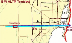
Dade County E-W Transect
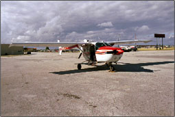
2000 Dade County E-W Transect In March of the 2000, FIU deployed the ALTM 1210 system in Miami-Dade County in order to test the capabilities of the LIDAR system in a variety of…
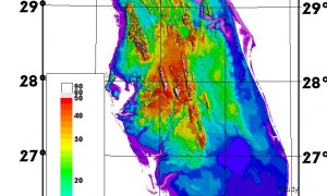
An Airborne Laser Topographic Mapping Study of Eastern Broward County, Florida With Applications to Hurricane Storm Surge Hazard
Introduction Accurate topographic information is essential for predicting storm surge damage and flooding. This data is an important component for the construction of evacuation maps based on hurricane storm surge models such as…
Animation and Visualization
Computer visualization can play an important role in educating the public about the storm surge hazard. More than 85% of the current coastal population has never experienced a direct hit by a hurricane….
Storm Surge Model Evaluation
Airborne LIDAR data have already resulted in considerable improvements in hurricane storm surge mapping. These data are an order of magnitude more accurate vertically (6 inches compared to 5 feet) and are much…
Airborne LIDAR Mapping
Airborne LIDAR Mapping The greatest hazard to human life posed by hurricanes is drowning in a storm surge. Historically, surge has accounted for more than 90 percent of fatalities. Salt-water flooding is also…

Coastal Research Project Report and Data
LIDAR Data The International Hurricane Research Center’s Laboratory for Coastal Research has made all completed LIDAR elevation data available online.These data were produced as part of the Windstorm Simulation Modeling Project per the…
This Could Very Well be an Article
Vestibulum erat mi, pulvinar ut dapibus vitae, mollis dignissim ante. Nullam fermentum ornare metus auctor faucibus. Proin nec massa vel orci iaculis aliquet accumsan ut neque. Vestibulum ante ipsum primis in faucibus orci…
Windstorm Simulation Project
Major funding from the Federal Emergency Management Agency (FEMA) through the Florida Department of Community Affairs (DCA). Project Overview The International Hurricane Research Center’s Windstorm Simulation and Modeling Project was funded by the…